
08-18-2009, 08:23 AM
|
 |
|
|
Join Date: May 2007
Location: WMU 303
Posts: 8,495
|
|

Quote:
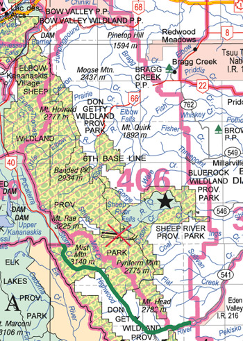
Elbow Wildlife Management Unit (406)
Commencing where the Highwood River crosses the eastern boundary of the Green Area; thence upstream along the right bank of the Highwood River to its closest point with the height of land of the Highwood range; thence northerly along the height of land to the summit of the Highwood range; thence northwesterly along the summit of the Highwood range to the height of land between the Highwood River drainage and the Kananaskis River drainage; thence northerly along the height of land between the Kananaskis River drainage and the Sheep River, Elbow River and Jumpingpound Creek drainages, to the southeastern boundary of the Stony Indian Reserve No. 142, 143 and 144; thence northeasterly along the southeastern boundary of the Stony Indian Reserve to the eastern boundary of the Green Area; thence easterly and southerly along the eastern boundary of the Green Area to the point of commencement.
|
You don't need the Wildlife Act for legal land description. This is from the regs and the regs contain the legal description. I can see though if you don't know the area at all it may be difficult to follow the boundries. I'm not a Flamer so I can't help you with the area 

|