 |

01-30-2012, 08:00 PM
|
|
|
|
Join Date: May 2011
Posts: 67
|
|
 Topographic Maps
Anyone know a good place/website to get affordable (or free) topographic maps?
|
01-30-2012, 08:04 PM
|
|
|
|
Join Date: Mar 2008
Location: South Alberta
Posts: 288
|
|
Alberta SRD(just google it) has some topo maps that are pretty decent, just a limited number of lakes.
|
01-30-2012, 08:08 PM
|
|
|
|
Join Date: Aug 2009
Location: High River, AB
Posts: 222
|
|
If you own an Iphone go to the app store and upload "Topographics maps Canada" it's free. Once you have upload the app, you just upload the areas you want.
|
01-30-2012, 08:10 PM
|
|
|
|
Join Date: Jan 2012
Location: Calgary
Posts: 91
|
|
Depending how accurate of a topo map you need, Google Maps has a terrain option for most areas.
ex: http://maps.google.ca/maps?q=banff&h...berta&t=p&z=13
__________________
Hunting: Hiking with guns.
|
01-30-2012, 08:15 PM
|
|
Banned
|
|
Join Date: Mar 2010
Location: on a mishn for fishn.
Posts: 8,790
|
|
the android app back country navigator is 10$ and works fantastic even in areas with out cell phone coverage.
|
01-30-2012, 08:20 PM
|
|
|
|
Join Date: Feb 2008
Posts: 102
|
|
If your looking for lakes use anglersatlas.com
|
01-30-2012, 08:21 PM
|
|
|
|
Join Date: May 2011
Posts: 67
|
|
great tips! thanks!
|
01-30-2012, 08:29 PM
|
|
|
|
Join Date: May 2011
Posts: 67
|
|
I'm looking specifically for topo maps of lake beds.
|
01-30-2012, 08:39 PM
|
|
Banned
|
|
Join Date: Oct 2010
Location: Edmonton
Posts: 4,018
|
|
Quote:
Originally Posted by N8orDie

I'm looking specifically for topo maps of lake beds.
|
then you want angler atlas.
Last edited by horsetrader; 01-30-2012 at 08:52 PM.
|
01-30-2012, 08:39 PM
|
|
Banned
|
|
Join Date: Mar 2010
Location: on a mishn for fishn.
Posts: 8,790
|
|
there is a great series of books, lakes, rivers and streams of alberta,that contain bathomertic charts of every major body of water in the books region.
|
01-30-2012, 08:43 PM
|
|
|
|
Join Date: Feb 2008
Posts: 102
|
|
anglersatlas works then. If you can't find your lake through the search, click map search and zoom in on the area you would like to search, when you zoom to at least level 9 click show lake and the ones that appear with a blue pin will have a topo attached but you will need a simple user name to access them.
Cheers
|
01-30-2012, 09:12 PM
|
|
Banned
|
|
Join Date: Apr 2011
Posts: 215
|
|
|
01-30-2012, 09:13 PM
|
 |
|
|
Join Date: Oct 2009
Posts: 954
|
|
Quote:
Originally Posted by Hairball
If you own an Iphone go to the app store and upload "Topographics maps Canada" it's free. Once you have upload the app, you just upload the areas you want.
|
I have that one. Just to add, it is GPS linked.
If you are on a lake and find a good spot, just mark it and you can go right back to the spot next time.
|
01-30-2012, 09:29 PM
|
 |
|
|
Join Date: Sep 2010
Location: Camrose
Posts: 2,359
|
|
navionics app for iphone is pretty decent, you can see exactly where you are through gps while you're out on the lake, which is nice. I recently found a very small shelf shown on the map while ice fishing, it was exactly where the map said it was. drilled 4 holes very close together, and it went from 8 feet to 15 feet, just like the app said
|
01-31-2012, 05:44 PM
|
|
|
|
Join Date: Aug 2009
Location: High River, AB
Posts: 222
|
|
Quote:
Originally Posted by fish farmer
|
Due they have this for Chain lakes? can't seem to find if they do or don't.
|
01-31-2012, 06:38 PM
|
|
Banned
|
|
Join Date: Apr 2011
Posts: 215
|
|
Quote:
Originally Posted by Hairball
Due they have this for Chain lakes? can't seem to find if they do or don't.
|
What's there is there. If it's not listed then they dont have it.
|
01-31-2012, 07:52 PM
|
 |
|
|
Join Date: Nov 2009
Location: Southern Alberta
Posts: 1,789
|
|
Quote:
Originally Posted by Hairball
Due they have this for Chain lakes? can't seem to find if they do or don't.
|
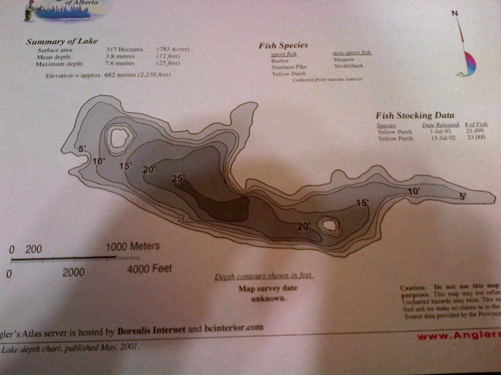
http://www.anglersatlas.com/lakes/7356/
|
01-31-2012, 08:15 PM
|
|
|
|
Join Date: Aug 2009
Location: High River, AB
Posts: 222
|
|
Quote:
Originally Posted by MoFugger21
|
thxs Mo.....
I signed up for this site.....very cool!!
|
02-01-2012, 02:16 PM
|
|
|
|
Join Date: Jun 2007
Location: Edmonton
Posts: 281
|
|
|
02-01-2012, 03:55 PM
|
|
|
|
Join Date: May 2011
Posts: 1,946
|
|
I find the "Atlas of Alberta Lakes" book to have OK maps. a bit dated but still I find some useful info and History there. The URL is
http://alberta-lakes.sunsite.ualberta.ca/
An example of a map, which is usually fig 1 or 2 of the "Lake Basin Characteristics" page of a certain lake.
http://sunsite.ualberta.ca/Projects/...?region=Beaver River Region&basin=Beaver River Basin&lake=Cold Lake&number=56&page=Lake_char#
You can also find rivers creeks and direction of flow diagrams under "Drainage Basin Characteristics"
Hope this helps.
|
 Posting Rules
|
You may not post new threads
You may not post replies
You may not post attachments
You may not edit your posts
HTML code is Off
|
|
|
All times are GMT -6. The time now is 08:00 AM.
|


 Linear Mode

